
Our services
We offer services mainly in the RCMs of Brome-Missisquoi, La Haute-Yamaska, Rouville, Memphremagog, Val-Saint-François, Acton and Maskoutains.
Our firm uses state-of-the-art instruments combined with high-performance software to provide our clients with a range of high quality surveying services.
Residential
Our services cover all the surveying needs of any owner wishing to proceed with a sale as well as the construction or expansion of a house or other structure. The establishment of the position of the buildings in relation to the property limits as well as the respect of the laws and regulations in force done by an expert in the field provides peace of mind to the owner.
Commercial, industrial and civil engineering
Since its establishment, Migué & Fournier, Land Surveyors Inc. has been keen to offer a full range of surveying services for companies wishing to establish themselves or make structural changes. In addition, we offer personalized monitoring of subdivision projects, from the drawing and topographic survey to the official implantation. All projects are monitored at the level of the developer, collaborators and at the municipal level to ensure the integrity and legality of the projects.
Migué & Fournier, Land Surveyors Inc. offers construction surveying services and has its RBQ license (#5750-5711-01)
Our construction services include:
- Implantation on site
- Implantation and geometric integration
- Calculation of volumes
- Construction site surveillance
- Infrastructure location
Government bodies
Our company also deploys its service offering for provincial government bodies, as well as for municipalities. The rigor and professionalism that drive us have always ensured collaborations that met the expectations of our customers.
Certificate of localisation
The certificate of location is a document comprising a plan and a report, in which the land surveyor expresses his opinion on the situation and the current condition of a property in relation to the title deeds, the cadastre, as well as laws and regulations that may affect it. It cannot be used or invoked for purposes other than those for which it is intended
This document is very often requested by a legal advisor (notary or lawyer), a mortgage lender, a buyer or a seller of a property. In general practice, the seller is required to provide an up-to-date certificate of location to the buyer in order to confirm that the “land” health of the property complies with the various legal entities that may affect it (law, regulation, servitude, etc.).
The certificate of location can also be requested by a municipality, to complete the fbuilding permit file.
Implantation (project plan and certificate)
(project plan and certificate)
The Implantation is the ensemble of the surveying operations carried out by the land surveyor with the aim of positioning and materializing the exact site of a structure or a detail of a structure to be erected or modified, in relation to the limits of a property, to another existing structure or to other reference lines in order to comply with the laws and regulations that may affect it.
A new construction or expansion project can be divided into three successive stages, the objectives of which are as follows:
- Check the feasibility of your project and obtain approval from your municipality: you will need a project implantation plan
- Proceed with the implantation of the constructions planned on your property and certify the operation: we will have to proceed with the implantation and issue you a Certificate of implantation
- Check the conformity of the work once the constructions have been erected (at the request of the municipality or the mortgagee): you will need a plan or a certificate of location
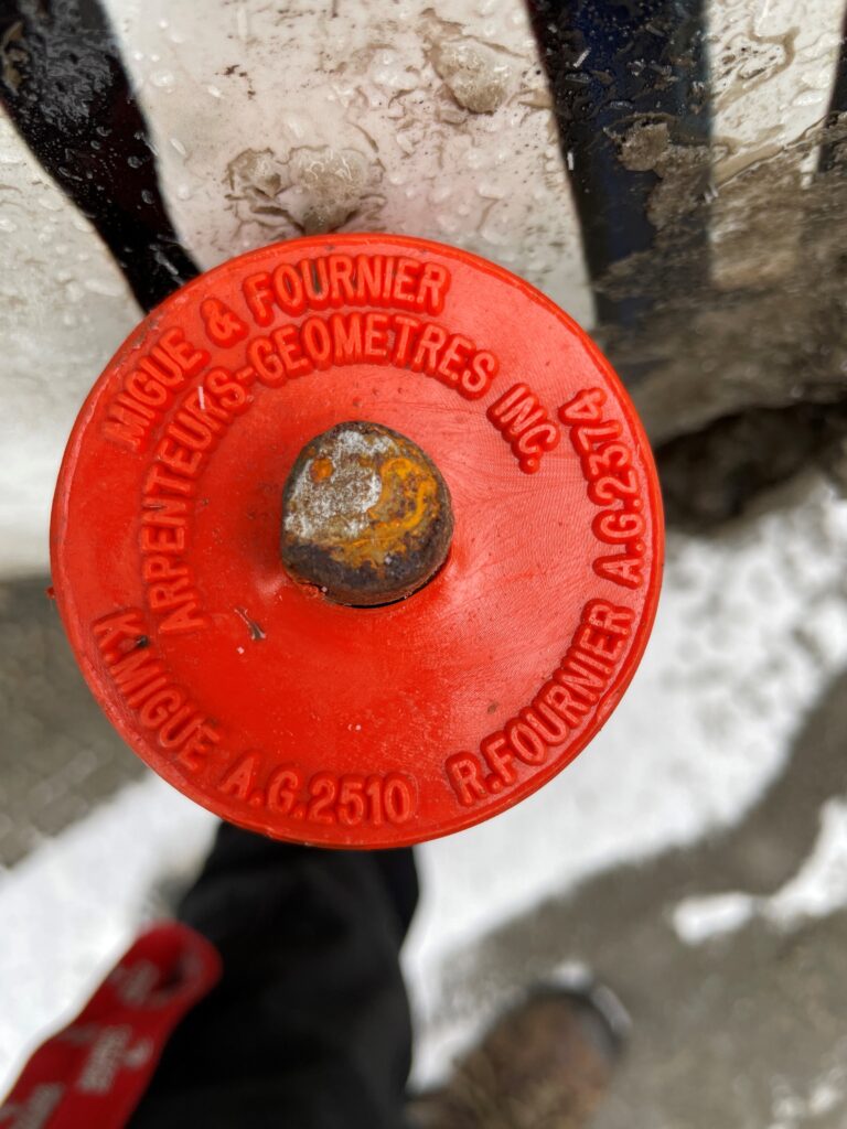
Staking
Staking is the ensemble of the surveying operations carried out by the land surveyor in order to indicate his opinion, by means of landmarks (commonly called “marker”), on the limits of a property existing or proposed property or a dismembered interest in such land.
Staking is valid for the sole benefit of the client or his mandator.
The marker placed during staking is an object planted to indicate any alignment or to mark the ends of straight lines or arcs of curves forming the perimeter of a plot of land. It must :
a) Be metalic
b) Be of square or circular in section
c) be uncored or treated against corrosion if hollowed out
d) Measure at least 60 centimeters in length and 15 milimeters ona side or in diameter
e) be equipped with a sleeve of at least three centimeters on each side or a cap of at least five centimeters in diameter, permanently attached to its upper part, on which the following minimum information is engraved: the initial or the initials of the first name of the land surveyor as well as his surname followed by the letters, a.-g.
f) be easily found, either by the fact that it exceeds the ground, or by the fact that it can be detected by a detector or by the fact that it has been sufficiently linked to physical details duly described in the notes. Following the placement of the markers, a staking certificate is prepared by the land surveyor and given to the client
Following the installation of the markers, a staking certificate is prepared by the land surveyor and given to the client.
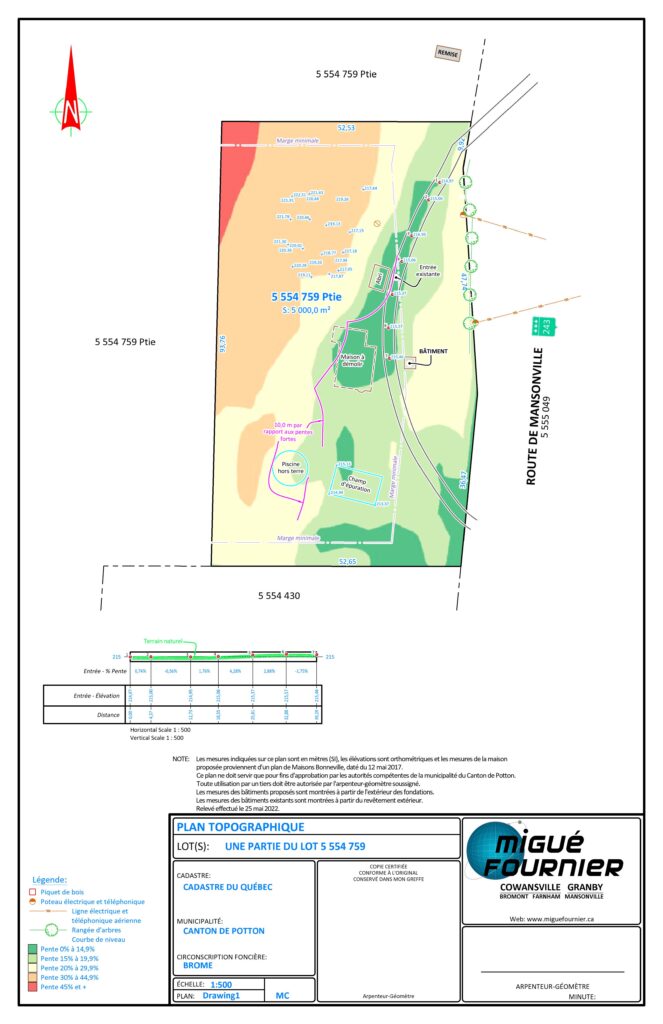
Topographic Plan
The topographic plan includes all the topography surveyed on the ground. Here we find buildings, waterways, communication routes, contour lines, etc. This plan is of primary use for professionals such as architects and landscapers in the development of a project according to the conditions of the land.
The topographic plan of course includes the position and elevations of the elements forming the terrain and can be useful in determining a flood zone or the percentage of slope in order to determine the location of a future structure.
This type of plan can be made from data collected in the field, by drone or by using LiDAR data.
Technical Description
The technical description is a document comprising a plan and a report, in which the land surveyor describes a property in relation to the cadastral limits and for specific purposes such as: easement of passage, easement of drainage, easement of encroachment, agricultural zoning, cultural property, annexation, sale or municipal merger. It cannot be used for purposes other than those for which it is intended.
Land designation is also a plan and report document, in which the land surveyor describes a property in relation to the titles and the cadastre. Mention must also be made of the existence or not of a ground survey. Although less precise than the technical description in the absence of ground survey, it is very often used for real estate transactions to meet certain specific purposes.
CONSTRUCTION SURVEYING / MAJOR PROJECTS
Migué & Fournier, Land Surveyors Inc. offers construction surveying services and has its RBQ license (#5750-5711-01)
Our construction services include:
- Implantation on site
- Implantation and geometric integration
- Calculation of volumes
- Construction site surveillance
- Location of infrastructure
SUBDIVISION / CADASTRAL OPERATION
The cadastre of Quebec represents your property on a plan and identifies it by a lot number. This plan shows the measurements, area, shape and position of this property in relation to neighboring properties. The cadastre is a state register made up of several plans and documents prepared by land surveyors.
It is possible for an owner to proceed to the “division” of his land in order to form several other building plots or not, which he can resell later. Under the Planning and Town Planning Act (Article 115), municipalities have the power to regulate the subdivision in their territory, to define the minimum width, depth and surface area, depending on the type of permitted use. In order to see to the preparation of the documents to be submitted for obtaining a municipal subdivision permit, the owner must call on the land surveyor. The latter will configure the desired dividing up.
Whether for the creation of homes, industrial or commercial establishments, parks and streets or plots to be transferred, a subdivision project plan is generally prepared in the early stages of the project and evolves until its final version before proceeding with the cadastral operations which will allow the desired transactions.
Boundary determination
boundary determination minutes
Operation carried out by a land surveyor aimed at establishing, in a permanent and irrevocable manner, the boundary between two contiguous properties by marking the land by means of markers, and by registering the rights thus established. Here, a distinction should be made between amicable boundary determination and judicial boundary determination.
The major differences with staking are that the boundary determination is done bilaterally (the two neighbors sign the document) and that it is public and enforceable against third parties (published in the Quebec land register).
Under article 978 of the Civil Code of Quebec, “any owner may compel his neighbor to mark the boundaries of their contiguous properties in order to establish boundaries, reestablish displaced or disappeared boundaries, recognize former boundaries or rectify the dividing line from their funds. »
LOCATION OF ZONES OF CONSTRAINT (FLOOD ZONE - SHORELINE PROTECTION STRIP)
Several rivers and lakes in Quebec have been instrumented and elevations have been determined for the 2, 5, 20 and 100 year flood zones. Each of these zones has specific restrictions and we have the expertise to locate said zones either for a new construction project or a localization on already constructed land.
In addition, the transitional regime for the management of flood-prone areas, banks and shorelines, the provisions of which are generally incorporated into municipal regulations, provides for the establishment of a shoreline protection strip from the high water mark of a body of water. Migué & Fournier, Land Surveyors Inc. is also qualified to determine the location of this shoreline protection strip and to position it in relation to the cadastre and adjacent buildings.
Additional Expertise
Co-ownership - Condo
Co-ownership is a form of ownership under which the ownership of real estate is divided by lots between the co-owners. The term co-ownership commonly designates, in practice, the legal regime relating to this form of ownership. The creation of a divided co-ownership is a relatively long and complex process that involves the participation of several professionals, including the land surveyor.
Divided co-ownership is used in Quebec to designate “Condo” type co-ownership. Divided co-ownership is often used to oppose undivided co-ownership, which erroneously designates another mode of ownership under which several people own the same property or the same set of properties without material division thereof. In divided co-ownership, each of the owners will own a private portion (condos) and a share of the common portion (parking, walls, etc.). Undivided co-ownership is seen more frequently when two people decide to buy a house equally. These two modes of ownership each have their own characteristics and should not be put in opposition since the notions are not contrary.
DRONE
Migué & Fournier, Land Surveyors Inc. offers its customers the service of drone surveys for specific projects, in business partnership with the firm Drone Diffusions inc., whose offices are located in Granby. The images and terrain information obtained by the drone offer an accuracy of up to 2 cm horizontally. The applications of this service are multiple for agriculture (drainage, yield, growth management, etc.), trade (tourism, archaeology, protected areas, development of ski slopes, quarries and sandpits, etc.).
Possibles fields of application (among others) :
- Residential
- Commercial
- Industrial
- Agricultural
- Mining industry
- Video surveillance
- Photogrammetry
- Digital terrain model and volume calculation
- Orthomosaic
Digital terrain model (DTM)
The digital terrain model (DTM) is a three-dimensional (3D) computer model representing the terrain over a specific region/surface. From this model, it is possible to visualize the appearance of the relief, calculate slopes, level curves or volume.
ROAD MAP
Migué & Fournier, Land Surveyors Inc. offers services to various government bodies in the preparation of, among other things, plans of right-of-way (property limit), acquisition plan in projects for the acquisition of plots of land and plan of surplus buildings with a view to transferring or sell certain plots of land to neighboring owners.
Photograph (with geolocalisation and orientation)
Migué & Fournier, Land Surveyors Inc. offers specialized services in taking high-quality geolocated photographs to obtain orientation, position and image quality information on a given site. The position and orientation of a photo transferred to a map can be useful both in the legal and technical fields.
Cadastral renovation
For more than twenty years now, the Quebec Ministry of Natural Resources has been preparing a new cadastral plan where each property is represented separately. The work currently being done in the province is entrusted to private land surveying firms. The owners do not have to pay anything for the cadastre reform work, but they have certain duties, including collaborating and participating in public consultations.
Our firm has actively participated in this process, sometimes as a land expert, particularly in the Farnham, Bedford and Sutton regions.